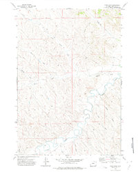
1971 Map of Fawn Draw
USGS Topo · Published 1975About this map
Clear Creek meanders across the lower portion of this Sheridan County landscape, serving as the primary drainage for a network of complex draws and gulches. In the early 1970s, this area remained largely open range, defined by its water sources and livestock infrastructure. Numerous scattered sites labeled Well indicate the importance of groundwater in this arid terrain. Topographically, the map reveals a dissected upland where features like Olsen Draw, Whedon Draw, and Buffalo Draw converge toward larger water bodies. To the north, the North Fork and South Fork begin to shape the headwaters of the regional creek system. The presence of fine red dashed lines throughout the quadrangle denotes selected fence lines, illustrating the 20th-century partitioning of the Wyoming ranching country into distinct grazing allotments and private holdings.
Find a feature on this map
20 named features on this map. Tap any name to fly to it.
Don’t see what you’re looking for? This feature index may not catch every label — zoom into the map to look around manually.
Map Details
Editions of this 1971 Fawn Draw Map
This is the sole edition of this map. No revisions or reprints were ever made.
Other maps of this area

1955 · Sheridan
USGS Topo · 1:250,000

1958 · Sheridan
USGS Topo · 1:250,000

1962 · Sheridan
USGS Topo · 1:250,000

1971 · Cabin Creek NW
USGS Topo · 1:24,000

1971 · Cabin Creek SE
USGS Topo · 1:24,000
1971 · Cabin Creek NE
USGS Topo · 1:24,000

1971 · Arvada
USGS Topo · 1:24,000

1971 · Gardner Gulch
USGS Topo · 1:24,000

1971 · Leiter
USGS Topo · 1:24,000
1971 · Box Elder Draw
USGS Topo · 1:24,000