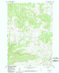
1960 Map of Granite Pass
USGS Topo · Published 1986About this map
The Bighorn National Forest landscape across the Sheridan and Big Horn county lines is dominated by high-altitude drainages and dramatic geological features as they appeared in 1960. Water systems including Bull Creek, Big Willow Creek, and Willey Creek carve through the terrain, originating from sources like Three Springs. The map highlights significant landforms such as Bear Rocks and the distinct peak of Copmans Tomb in the south. Surveyors documented the high point at VABM 9774 Prospect and the strategic location of Granite Pass at the southeastern edge of the quadrangle. This 1960 survey, field-checked just before the era of widespread road expansion, preserves the natural hydrology of the area, showing the intricate network of tributaries like Owen Creek and Little Willow Creek before modern intervention altered the backcountry character.
Find a feature on this map
21 named features on this map. Tap any name to fly to it.
Don’t see what you’re looking for? This feature index may not catch every label — zoom into the map to look around manually.
Map Details
Editions of this 1960 Granite Pass Map
2 editions found
Other maps of this area

1895 · Dayton
USGS Topo · 1:125,000

1898 · Bald Mountain
USGS Topo · 1:125,000

1901 · Dayton
USGS Topo · 1:125,000

1901 · Bald Mountain
USGS Topo · 1:125,000

1955 · Sheridan
USGS Topo · 1:250,000

1958 · Sheridan
USGS Topo · 1:250,000

1960 · Shell Falls
USGS Topo · 1:24,000

1960 · Black Mountain
USGS Topo · 1:24,000

1960 · Granite Pass
USGS Topo · 1:24,000

1960 · Hidden Tepee Creek
USGS Topo · 1:24,000