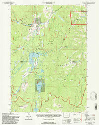
1993 Map of Park Reservoir
USGS Topo · Published 1997About this map
Bighorn National Forest hosts a high-altitude landscape of water management and mountain recreation in this early 1990s survey. The map centers on the critical storage capacity of Park Reservoir and Bighorn Reservoir, which are linked by an intricate network of water diversion infrastructure including the Penalta Ditch and Reservoir Ditch. These alpine waters, fed by numerous streams like Big Goose Creek and Granite Creek, serve as the lifeblood for the lower valleys of Sheridan Co and Johnson Co.
Find a feature on this map
47 named features on this map. Tap any name to fly to it.
Don’t see what you’re looking for? This feature index may not catch every label — zoom into the map to look around manually.
Map Details
Editions of this 1993 Park Reservoir Map
This is the sole edition of this map. No revisions or reprints were ever made.
Other maps of this area

1895 · Dayton
USGS Topo · 1:125,000

1899 · Cloud peak
USGS Topo · 1:125,000

1901 · Cloud Peak
USGS Topo · 1:125,000

1901 · Dayton
USGS Topo · 1:125,000

1955 · Sheridan
USGS Topo · 1:250,000

1958 · Sheridan
USGS Topo · 1:250,000

1960 · Shell Lake
USGS Topo · 1:24,000

1962 · Sheridan
USGS Topo · 1:250,000

1964 · Walker Mountain
USGS Topo · 1:24,000

1964 · Beckton
USGS Topo · 1:24,000