
1965 Map of Little Goose Peak
USGS Topo · Published 1991About this map
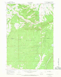
Bighorn National Forest defines this high-elevation landscape straddling the boundary of Sheridan and Johnson counties. The terrain is characterized by a complex network of canyons and peaks, anchored by the prominent Little Goose Peak and the deep Black Canyon. Water management and historical military movements are central to this area's story, evidenced by the presence of the Historical Site (Gen Crooks Camp) and several water-diversion features like Last Chance Ditch and the Gaging Sta.
Find a feature on this map
36 named features on this map. Tap any name to fly to it.
Don’t see what you’re looking for? This feature index may not catch every label — zoom into the map to look around manually.
Map Details
Editions of this 1965 Little Goose Peak Map
2 editions found
Historical Maps of Sheridan County Through Time
273 maps found

1960 Bald Mountain
Sheridan County, WY

1960 Boyd Ridge
Sheridan County, WY

1960 Granite Pass
Sheridan County, WY

1964 Beaver Creek Hills
Sheridan County, WY

1964 Beckton
Sheridan County, WY

1964 Bull Elk Park
Sheridan County, WY

1964 Burgess Junction
Sheridan County, WY

1964 Columbus Peak
Sheridan County, WY

1964 Dayton North
Sheridan County, WY

1964 Dayton South
Sheridan County, WY

1964 Dome Lake
Sheridan County, WY

1964 Hultz Draw
Sheridan County, WY

1964 Ice Creek
Sheridan County, WY

1964 Monarch
Sheridan County, WY

1964 Skull Ridge
Sheridan County, WY

1964 Walker Mountain
Sheridan County, WY

1964 West Pass
Sheridan County, WY

1964 Wolf
Sheridan County, WY

1964 Woodrock
Sheridan County, WY
1965 Little Goose Peak
Sheridan County, WY

1965 Park Reservoir
Sheridan County, WY

1967 Banner
Sheridan County, WY

1967 Buffalo Run Creek
Sheridan County, WY

1968 Acme
Sheridan County, WY

1968 Bar N Draw
Sheridan County, WY

1968 Wyarno
Sheridan County, WY

1970 Burgess Junction
Sheridan County, WY

1970 Cedar Canyon
Sheridan County, WY

1970 Horse Hill
Sheridan County, WY

1970 Jones Draw
Sheridan County, WY

1970 O T O Ranch
Sheridan County, WY

1970 S R Springs
Sheridan County, WY

1970 Ucross
Sheridan County, WY

1970 Ulm
Sheridan County, WY

1970 Verona
Sheridan County, WY

1971 Arvada NE
Sheridan County, WY

1971 Box Elder Draw
Sheridan County, WY

1971 Cabin Creek NE
Sheridan County, WY

1971 Cabin Creek NW
Sheridan County, WY

1971 Cabin Creek SE
Sheridan County, WY

1971 Fawn Draw
Sheridan County, WY

1971 Gardner Gulch
Sheridan County, WY

1971 Julio Draw
Sheridan County, WY

1971 Leiter
Sheridan County, WY

1971 Roundup Draw
Sheridan County, WY

1971 Shuler Draw
Sheridan County, WY

1972 Arpan Butte
Sheridan County, WY

1972 Jewell Draw
Sheridan County, WY

1972 Lariat
Sheridan County, WY

1979 Burgess Junction
Sheridan County, WY

1993 Bald Mountain
Sheridan County, WY

1993 Beaver Creek Hills
Sheridan County, WY

1993 Beckton
Sheridan County, WY

1993 Boyd Ridge
Sheridan County, WY

1993 Bull Elk Park
Sheridan County, WY

1993 Burgess Junction
Sheridan County, WY

1993 Columbus Peak
Sheridan County, WY

1993 Dayton South
Sheridan County, WY

1993 Dome Lake
Sheridan County, WY

1993 Granite Pass
Sheridan County, WY

1993 Ice Creek
Sheridan County, WY

1993 Little Goose Peak
Sheridan County, WY

1993 Park Reservoir
Sheridan County, WY

1993 Skull Ridge
Sheridan County, WY

1993 Walker Mountain
Sheridan County, WY

1993 West Pass
Sheridan County, WY

1993 Wolf
Sheridan County, WY

1993 Woodrock
Sheridan County, WY

2011 Acme
Sheridan County, WY

2011 Bar N Draw
Sheridan County, WY

2011 Box Elder Draw
Sheridan County, WY

2011 Cabin Creek NE
Sheridan County, WY

2011 Cabin Creek NW
Sheridan County, WY

2011 Cedar Canyon
Sheridan County, WY

2011 Dayton North
Sheridan County, WY

2011 Monarch
Sheridan County, WY

2011 O T O Ranch
Sheridan County, WY

2011 Roundup Draw
Sheridan County, WY

2012 Acme
Sheridan County, WY

2012 Arpan Butte
Sheridan County, WY

2012 Arvada NE
Sheridan County, WY

2012 Bald Mountain
Sheridan County, WY

2012 Banner
Sheridan County, WY

2012 Bar N Draw
Sheridan County, WY

2012 Beaver Creek Hills
Sheridan County, WY

2012 Beckton
Sheridan County, WY

2012 Box Elder Draw
Sheridan County, WY

2012 Boyd Ridge
Sheridan County, WY

2012 Buffalo Run Creek
Sheridan County, WY

2012 Bull Elk Park
Sheridan County, WY

2012 Burgess Junction
Sheridan County, WY

2012 Cabin Creek NE
Sheridan County, WY

2012 Cabin Creek NW
Sheridan County, WY

2012 Cabin Creek SE
Sheridan County, WY

2012 Cedar Canyon
Sheridan County, WY

2012 Columbus Peak
Sheridan County, WY

2012 Dayton North
Sheridan County, WY

2012 Dayton South
Sheridan County, WY

2012 Dome Lake
Sheridan County, WY

2012 Fawn Draw
Sheridan County, WY

2012 Gardner Gulch
Sheridan County, WY

2012 Granite Pass
Sheridan County, WY

2012 Horse Hill
Sheridan County, WY

2012 Hultz Draw
Sheridan County, WY

2012 Ice Creek
Sheridan County, WY

2012 Jewell Draw
Sheridan County, WY

2012 Jones Draw
Sheridan County, WY

2012 Julio Draw
Sheridan County, WY

2012 Lariat
Sheridan County, WY

2012 Leiter
Sheridan County, WY

2012 Little Goose Peak
Sheridan County, WY

2012 Monarch
Sheridan County, WY

2012 O T O Ranch
Sheridan County, WY

2012 Park Reservoir
Sheridan County, WY

2012 Roundup Draw
Sheridan County, WY

2012 Shuler Draw
Sheridan County, WY

2012 Skull Ridge
Sheridan County, WY

2012 S R Springs
Sheridan County, WY

2012 Ucross
Sheridan County, WY

2012 Ulm
Sheridan County, WY

2012 Verona
Sheridan County, WY

2012 Walker Mountain
Sheridan County, WY

2012 West Pass
Sheridan County, WY

2012 Wolf
Sheridan County, WY

2012 Woodrock
Sheridan County, WY

2012 Wyarno
Sheridan County, WY

2015 Acme
Sheridan County, WY

2015 Arpan Butte
Sheridan County, WY

2015 Arvada NE
Sheridan County, WY

2015 Bald Mountain
Sheridan County, WY

2015 Banner
Sheridan County, WY

2015 Bar N Draw
Sheridan County, WY

2015 Beaver Creek Hills
Sheridan County, WY

2015 Beckton
Sheridan County, WY

2015 Box Elder Draw
Sheridan County, WY

2015 Boyd Ridge
Sheridan County, WY

2015 Buffalo Run Creek
Sheridan County, WY

2015 Bull Elk Park
Sheridan County, WY

2015 Burgess Junction
Sheridan County, WY

2015 Cabin Creek NE
Sheridan County, WY

2015 Cabin Creek NW
Sheridan County, WY

2015 Cabin Creek SE
Sheridan County, WY

2015 Cedar Canyon
Sheridan County, WY

2015 Columbus Peak
Sheridan County, WY

2015 Dayton North
Sheridan County, WY

2015 Dayton South
Sheridan County, WY

2015 Dome Lake
Sheridan County, WY

2015 Fawn Draw
Sheridan County, WY

2015 Gardner Gulch
Sheridan County, WY

2015 Granite Pass
Sheridan County, WY

2015 Horse Hill
Sheridan County, WY

2015 Hultz Draw
Sheridan County, WY

2015 Ice Creek
Sheridan County, WY

2015 Jewell Draw
Sheridan County, WY

2015 Jones Draw
Sheridan County, WY

2015 Julio Draw
Sheridan County, WY

2015 Lariat
Sheridan County, WY

2015 Leiter
Sheridan County, WY

2015 Little Goose Peak
Sheridan County, WY

2015 Monarch
Sheridan County, WY

2015 O T O Ranch
Sheridan County, WY

2015 Park Reservoir
Sheridan County, WY

2015 Roundup Draw
Sheridan County, WY

2015 Shuler Draw
Sheridan County, WY

2015 Skull Ridge
Sheridan County, WY

2015 S R Springs
Sheridan County, WY

2015 Ucross
Sheridan County, WY

2015 Ulm
Sheridan County, WY

2015 Verona
Sheridan County, WY

2015 Walker Mountain
Sheridan County, WY

2015 West Pass
Sheridan County, WY

2015 Wolf
Sheridan County, WY

2015 Woodrock
Sheridan County, WY

2015 Wyarno
Sheridan County, WY

2017 Acme
Sheridan County, WY

2017 Arpan Butte
Sheridan County, WY

2017 Arvada NE
Sheridan County, WY

2017 Bald Mountain
Sheridan County, WY

2017 Banner
Sheridan County, WY

2017 Bar N Draw
Sheridan County, WY

2017 Beckton
Sheridan County, WY

2017 Box Elder Draw
Sheridan County, WY

2017 Buffalo Run Creek
Sheridan County, WY

2017 Bull Elk Park
Sheridan County, WY

2017 Burgess Junction
Sheridan County, WY

2017 Cabin Creek NE
Sheridan County, WY

2017 Cabin Creek NW
Sheridan County, WY

2017 Cabin Creek SE
Sheridan County, WY

2017 Cedar Canyon
Sheridan County, WY

2017 Columbus Peak
Sheridan County, WY

2017 Dayton North
Sheridan County, WY

2017 Dayton South
Sheridan County, WY

2017 Dome Lake
Sheridan County, WY

2017 Fawn Draw
Sheridan County, WY

2017 Gardner Gulch
Sheridan County, WY

2017 Granite Pass
Sheridan County, WY

2017 Horse Hill
Sheridan County, WY

2017 Hultz Draw
Sheridan County, WY

2017 Ice Creek
Sheridan County, WY

2017 Jewell Draw
Sheridan County, WY

2017 Jones Draw
Sheridan County, WY

2017 Julio Draw
Sheridan County, WY

2017 Lariat
Sheridan County, WY

2017 Leiter
Sheridan County, WY

2017 Little Goose Peak
Sheridan County, WY

2017 Monarch
Sheridan County, WY

2017 O T O Ranch
Sheridan County, WY

2017 Park Reservoir
Sheridan County, WY

2017 Roundup Draw
Sheridan County, WY

2017 Shuler Draw
Sheridan County, WY

2017 Skull Ridge
Sheridan County, WY

2017 S R Springs
Sheridan County, WY

2017 Ucross
Sheridan County, WY

2017 Ulm
Sheridan County, WY

2017 Verona
Sheridan County, WY

2017 Walker Mountain
Sheridan County, WY

2017 West Pass
Sheridan County, WY

2017 Wolf
Sheridan County, WY

2017 Woodrock
Sheridan County, WY

2017 Wyarno
Sheridan County, WY

2018 Beaver Creek Hills
Sheridan County, WY

2018 Boyd Ridge
Sheridan County, WY

2021 Acme
Sheridan County, WY

2021 Arpan Butte
Sheridan County, WY

2021 Arvada NE
Sheridan County, WY

2021 Bald Mountain
Sheridan County, WY

2021 Banner
Sheridan County, WY

2021 Bar N Draw
Sheridan County, WY

2021 Beaver Creek Hills
Sheridan County, WY

2021 Beckton
Sheridan County, WY

2021 Box Elder Draw
Sheridan County, WY

2021 Boyd Ridge
Sheridan County, WY

2021 Buffalo Run Creek
Sheridan County, WY

2021 Bull Elk Park
Sheridan County, WY

2021 Burgess Junction
Sheridan County, WY

2021 Cabin Creek NE
Sheridan County, WY

2021 Cabin Creek NW
Sheridan County, WY

2021 Cabin Creek SE
Sheridan County, WY

2021 Cedar Canyon
Sheridan County, WY

2021 Columbus Peak
Sheridan County, WY

2021 Dayton North
Sheridan County, WY

2021 Dayton South
Sheridan County, WY

2021 Dome Lake
Sheridan County, WY

2021 Fawn Draw
Sheridan County, WY

2021 Gardner Gulch
Sheridan County, WY

2021 Granite Pass
Sheridan County, WY

2021 Horse Hill
Sheridan County, WY

2021 Hultz Draw
Sheridan County, WY

2021 Ice Creek
Sheridan County, WY

2021 Jewell Draw
Sheridan County, WY

2021 Jones Draw
Sheridan County, WY

2021 Julio Draw
Sheridan County, WY

2021 Lariat
Sheridan County, WY

2021 Leiter
Sheridan County, WY

2021 Little Goose Peak
Sheridan County, WY

2021 Monarch
Sheridan County, WY

2021 O T O Ranch
Sheridan County, WY

2021 Park Reservoir
Sheridan County, WY

2021 Roundup Draw
Sheridan County, WY

2021 Shuler Draw
Sheridan County, WY

2021 Skull Ridge
Sheridan County, WY

2021 S R Springs
Sheridan County, WY

2021 Ucross
Sheridan County, WY

2021 Ulm
Sheridan County, WY

2021 Verona
Sheridan County, WY

2021 Walker Mountain
Sheridan County, WY

2021 West Pass
Sheridan County, WY

2021 Wolf
Sheridan County, WY

2021 Woodrock
Sheridan County, WY

2021 Wyarno
Sheridan County, WY

2023 Cabin Creek NW
Sheridan County, WY

2023 Cabin Creek SE
Sheridan County, WY

2023 Fawn Draw
Sheridan County, WY