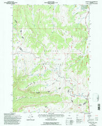
1993 Map of Granite Pass
USGS Topo · Published 1997About this map
Granite Pass serves as a high-altitude anchor for this 1993 study of the northern Wyoming highlands, where the boundary between Sheridan and Big Horn Counties bisects the landscape. The area is dominated by the Bighorn National Forest, specifically within the Medicine Wheel Paintrock Ranger District. The terrain is defined by a complex network of drainages, including Bull Creek, Big Willow Creek, and Three Springs Creek, which flow through the high country. Unlike more developed areas, this map emphasizes the resource management and infrastructure of the Forest Service, documenting numerous locations of Stock Tanks and Stock Ponds crucial for regional land use.
Find a feature on this map
38 named features on this map. Tap any name to fly to it.
Don’t see what you’re looking for? This feature index may not catch every label — zoom into the map to look around manually.
Map Details
Editions of this 1993 Granite Pass Map
This is the sole edition of this map. No revisions or reprints were ever made.
Other maps of this area

1895 · Dayton
USGS Topo · 1:125,000

1898 · Bald Mountain
USGS Topo · 1:125,000

1901 · Dayton
USGS Topo · 1:125,000

1901 · Bald Mountain
USGS Topo · 1:125,000

1955 · Sheridan
USGS Topo · 1:250,000

1958 · Sheridan
USGS Topo · 1:250,000

1960 · Shell Falls
USGS Topo · 1:24,000

1960 · Black Mountain
USGS Topo · 1:24,000

1960 · Granite Pass
USGS Topo · 1:24,000

1960 · Hidden Tepee Creek
USGS Topo · 1:24,000