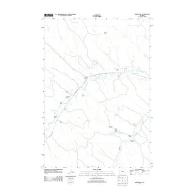
2012 Map of Horse Hill
USGS Topo · Published 2012About this map
Piney Cr and Boxelder Cr define the hydrological character of this Wyoming landscape, where an intricate network of irrigation canals supports the high-plains ranching economy. Significant water management features including the Athorpe Rogers Ditch, Maverick Ditch, and Boxelder Ditch illustrate the engineering required to sustain local agriculture. The terrain is marked by prominent elevations like Horse Hill and Snake Hill, which rise above a complex system of drainage features such as Williams Draw and Big Draw. Local livestock and irrigation needs are further evidenced by the presence of the Big Draw Reservoir and the two Belus Number 1 and Belus Number 2 reservoirs. This rural area is connected by a web of functional arteries, including Hamilton Big Red Rd and Lower Piney Rd, providing insight into the movement and settlement patterns of Sheridan County at the start of the twenty-first century.
Find a feature on this map
35 named features on this map. Tap any name to fly to it.
Don’t see what you’re looking for? This feature index may not catch every label — zoom into the map to look around manually.
Map Details
Editions of this 2012 Horse Hill Map
This is the sole edition of this map. No revisions or reprints were ever made.
Other maps of this area

1900 · Fort McKinney
USGS Topo · 1:125,000

1903 · Fort McKinney
USGS Topo · 1:125,000

1909 · Sheridan
USGS Topo · 1:125,000

1911 · Sheridan
USGS Topo · 1:125,000

1955 · Sheridan
USGS Topo · 1:250,000

1958 · Sheridan
USGS Topo · 1:250,000

1962 · Sheridan
USGS Topo · 1:250,000

1967 · Buffalo Run Creek
USGS Topo · 1:24,000

1967 · Lake De Smet West
USGS Topo · 1:24,000
1967 · Banner
USGS Topo · 1:24,000