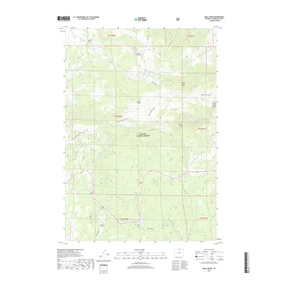
2017 Map of Skull Ridge
USGS Topo · Published 2017About this map
Bighorn National Forest defines the landscape of this region, where the Tongue River and its numerous tributaries carve through complex terrain. The geography is characterized by dramatic elevation changes, notably at Tongue River Canyon and Box Canyon. Water management and natural drainage patterns are evident through features like the Eureka Ditch and the concentration of creeks such as North Tongue River and South Tongue River that converge here. High-altitude clearings and landmarks, including Sawmill Flat, Shutts Flats, and Skull Ridge, provide a clear picture of the wilderness character of Sheridan County. Significant recreation and water resources like Sibley Lake are situated alongside Route 14, which serves as the primary corridor through these mountain reaches.
Find a feature on this map
43 named features on this map. Tap any name to fly to it.
Don’t see what you’re looking for? This feature index may not catch every label — zoom into the map to look around manually.
Map Details
Editions of this 2017 Skull Ridge Map
This is the sole edition of this map. No revisions or reprints were ever made.
Other maps of this area

1895 · Dayton
USGS Topo · 1:125,000

1898 · Bald Mountain
USGS Topo · 1:125,000

1901 · Dayton
USGS Topo · 1:125,000

1901 · Bald Mountain
USGS Topo · 1:125,000

1955 · Sheridan
USGS Topo · 1:250,000

1958 · Sheridan
USGS Topo · 1:250,000

1960 · Granite Pass
USGS Topo · 1:24,000

1962 · Sheridan
USGS Topo · 1:250,000
1964 · Burgess Junction
USGS Topo · 1:24,000
1964 · Dayton North
USGS Topo · 1:24,000