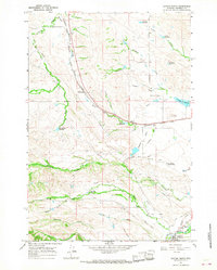
1964 Map of Dayton North
USGS Topo · Published 1967About this map
Parkman and Dayton serve as the primary hubs in this Sheridan County landscape, where the Chicago Burlington and Quincy railroad cuts a prominent path through the foothills. The map reveals an intricate network of irrigation essential for the local ranching economy, including the Five Mile Ditch, Brand Ditch, and Hanover No 1 Ditch. This infrastructure supports established holdings like Bear Claw Ranch and the Padlock Ranch, which features its own Landing Area near the banks of the Tongue River. Numerous reservoirs, such as Antwerp Reservoir and Barker Reservoir, are scattered across the draws and gulches, highlighting the critical role of water management in this high-plains environment. From the northern border with Montana down to the valley of Columbus Creek, the terrain is marked by industrial markers like Gravel Pits and the long-distance Pipeline corridor, reflecting a working landscape defined by transport and natural resource extraction.
Find a feature on this map
45 named features on this map. Tap any name to fly to it.
Don’t see what you’re looking for? This feature index may not catch every label — zoom into the map to look around manually.
Map Details
Editions of this 1964 Dayton North Map
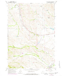
2 editions found
Other maps of this area

1894 · Rosebud
USGS Topo · 1:125,000

1895 · Dayton
USGS Topo · 1:125,000

1901 · Rosebud
USGS Topo · 1:125,000

1901 · Dayton
USGS Topo · 1:125,000

1954 · Hardin
USGS Topo · 1:250,000

1955 · Sheridan
USGS Topo · 1:250,000

1957 · Hardin
USGS Topo · 1:250,000

1958 · Hardin
USGS Topo · 1:250,000

1958 · Sheridan
USGS Topo · 1:250,000

1962 · Sheridan
USGS Topo · 1:250,000