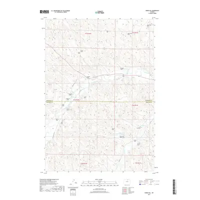
2017 Map of Horse Hill
USGS Topo · Published 2017About this map
Piney Creek and its complex network of irrigation channels define the agricultural landscape along the Sheridan and Johnson county line. The presence of numerous named water projects, such as Maverick Ditch and the WJD Ditch, highlights a high-country ranching economy dependent on diverted water. The terrain is a series of named draws and hills, ranging from Horse Hill in the north to the southern waters of Boxelder Cr. Land use is further evidenced by a system of man-made catchments including Big Draw Reservoir and the Belus Number 1 Reservoir. This 2017 survey details the intersection of early water rights, such as the Athorpe Rogers Ditch, and the local road network that follows the creek beds, including Lower Piney Creek Rd and Belus Rd.
Find a feature on this map
44 named features on this map. Tap any name to fly to it.
Don’t see what you’re looking for? This feature index may not catch every label — zoom into the map to look around manually.
Map Details
Editions of this 2017 Horse Hill Map
This is the sole edition of this map. No revisions or reprints were ever made.
Other maps of this area

1900 · Fort McKinney
USGS Topo · 1:125,000

1903 · Fort McKinney
USGS Topo · 1:125,000

1909 · Sheridan
USGS Topo · 1:125,000

1911 · Sheridan
USGS Topo · 1:125,000

1955 · Sheridan
USGS Topo · 1:250,000

1958 · Sheridan
USGS Topo · 1:250,000

1962 · Sheridan
USGS Topo · 1:250,000

1967 · Buffalo Run Creek
USGS Topo · 1:24,000

1967 · Lake De Smet West
USGS Topo · 1:24,000
1967 · Banner
USGS Topo · 1:24,000