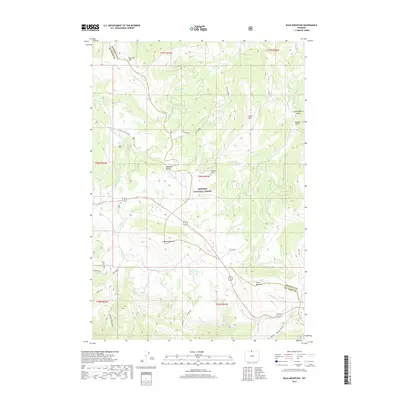
2017 Map of Bald Mountain
USGS Topo · Published 2017About this map
The high-altitude terrain of the Bighorn National Forest dominates this Wyoming landscape along the border of Big Horn and Sheridan counties. Centered on the broad, treeless prominence of Bald Mountain, the geography is defined by the headwaters of several major drainages, including the Little Bighorn River and the Little Horn. The northern reaches are punctuated by dramatic landmarks like Bucking Mule Falls and the summits of Duncum Mtn and Burnt Mtn.
Find a feature on this map
36 named features on this map. Tap any name to fly to it.
Don’t see what you’re looking for? This feature index may not catch every label — zoom into the map to look around manually.
Map Details
Editions of this 2017 Bald Mountain Map
This is the sole edition of this map. No revisions or reprints were ever made.
Other maps of this area

1898 · Bald Mountain
USGS Topo · 1:125,000

1901 · Bald Mountain
USGS Topo · 1:125,000

1955 · Sheridan
USGS Topo · 1:250,000

1958 · Sheridan
USGS Topo · 1:250,000

1960 · Medicine Wheel
USGS Topo · 1:24,000

1960 · Boyd Ridge
USGS Topo · 1:24,000

1960 · Mexican Hill
USGS Topo · 1:24,000

1960 · Hidden Tepee Creek
USGS Topo · 1:24,000

1960 · Bear Creek Ranch
USGS Topo · 1:24,000
1960 · Bald Mountain
USGS Topo · 1:24,000