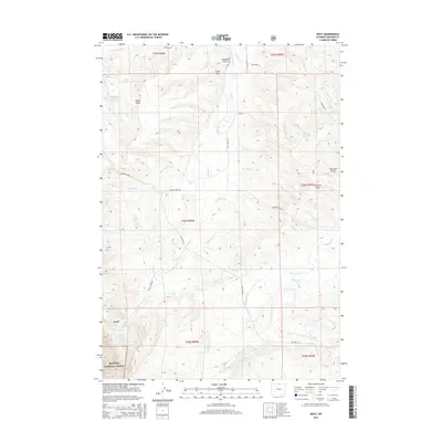
2015 Map of Wolf
USGS Topo · Published 2015About this map
Wolf sits at the foot of the Bighorn Mountains, where the high plains meet the eastern boundary of the Bighorn National Forest. This landscape is defined by an intricate network of irrigation systems and cattle ranching infrastructure, tracing the movement of water from the mountains to the valley floor. Numerous family-named and historical waterways like Grinnell Ditch, Old Reliable Ditch, and Garrard Ditch cut across the terrain, reflecting a long-established agricultural economy. The presence of the J and H Ranch Number 1 Reservoir and Hanff Reservoir emphasizes the importance of water storage in this arid environment. Significant natural features like Wolf Cr and Soldier Cr wind through deeply etched draws, such as Hanff Draw and Lowe Draw, providing a detailed look at the topographic character of Sheridan County during the mid-2010s.
Find a feature on this map
44 named features on this map. Tap any name to fly to it.
Don’t see what you’re looking for? This feature index may not catch every label — zoom into the map to look around manually.
Map Details
Editions of this 2015 Wolf Map
This is the sole edition of this map. No revisions or reprints were ever made.
Other maps of this area

1895 · Dayton
USGS Topo · 1:125,000

1901 · Dayton
USGS Topo · 1:125,000

1955 · Sheridan
USGS Topo · 1:250,000

1958 · Sheridan
USGS Topo · 1:250,000

1962 · Sheridan
USGS Topo · 1:250,000

1964 · Wolf
USGS Topo · 1:24,000
1964 · Ranchester
USGS Topo · 1:24,000
1964 · Dayton North
USGS Topo · 1:24,000
1964 · Monarch
USGS Topo · 1:24,000

1964 · Dayton South
USGS Topo · 1:24,000