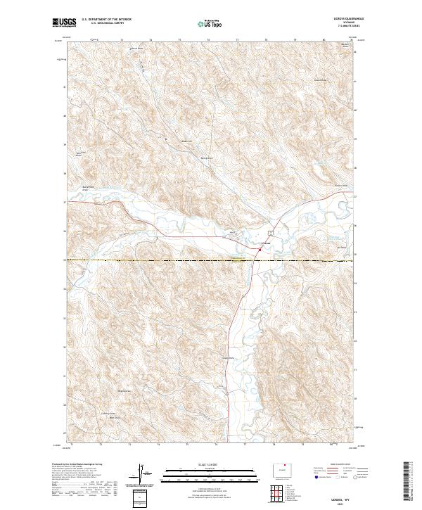
2021 Map of Ucross
USGS Topo · Published 2021About this map
Ucross sits at the confluence of Piney Creek and Clear Creek, serving as a focal point for a complex network of agricultural waterways near the Sheridan Co Johnson Co boundary. The landscape is defined by its sophisticated irrigation infrastructure, including the Pratt and Ferris Ditch Number 1, Big Bonanza Ditch, and Des Moines Ditch, which redirect water from the primary creeks to support local ranching and farming operations. To the north, prominent elevations like Blazer Hill rise above numerous drainages such as Donkey Cr and Spring Draw. The presence of smaller water management features, including the Pitsch Reservoir and Little Red Reservoir Number 2, alongside evocative road names like Rustlers Trl and Chuckwagon Trl, illustrates a region deeply tied to its cattle-ranching heritage and the careful stewardship of semi-arid lands.
Find a feature on this map
44 named features on this map. Tap any name to fly to it.
Don’t see what you’re looking for? This feature index may not catch every label — zoom into the map to look around manually.
Map Details
Editions of this 2021 Ucross Map
This is the sole edition of this map. No revisions or reprints were ever made.
Other maps of this area

1900 · Fort McKinney
USGS Topo · 1:125,000

1903 · Fort McKinney
USGS Topo · 1:125,000

1909 · Sheridan
USGS Topo · 1:125,000

1911 · Sheridan
USGS Topo · 1:125,000

1955 · Sheridan
USGS Topo · 1:250,000

1958 · Sheridan
USGS Topo · 1:250,000

1962 · Sheridan
USGS Topo · 1:250,000

1970 · Buffalo NE
USGS Topo · 1:24,000
1970 · Horse Hill
USGS Topo · 1:24,000
1970 · Verona
USGS Topo · 1:24,000