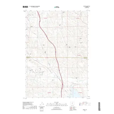
2017 Map of Banner
USGS Topo · Published 2017About this map
Banner sits at the intersection of a sprawling network of draws and gulches along the Sheridan and Johnson County line. This landscape is defined by its deep historical associations with the frontier era, marked by significant geographic points like Massacre Hill and Lodge Trail Ridge. The map details a complex system of early water management infrastructure, including the Upper Phil Kearny Ditch, Leiter Ditch, and Highline Ditch, which redirect water from Piney Creek to support the surrounding high plains.
Find a feature on this map
55 named features on this map. Tap any name to fly to it.
Don’t see what you’re looking for? This feature index may not catch every label — zoom into the map to look around manually.
Map Details
Editions of this 2017 Banner Map
This is the sole edition of this map. No revisions or reprints were ever made.
Other maps of this area

1900 · Fort McKinney
USGS Topo · 1:125,000

1903 · Fort McKinney
USGS Topo · 1:125,000

1909 · Sheridan
USGS Topo · 1:125,000

1911 · Sheridan
USGS Topo · 1:125,000

1955 · Sheridan
USGS Topo · 1:250,000

1958 · Sheridan
USGS Topo · 1:250,000

1962 · Sheridan
USGS Topo · 1:250,000

1967 · Buffalo Run Creek
USGS Topo · 1:24,000

1967 · Lake De Smet West
USGS Topo · 1:24,000
1967 · Stone Mountain
USGS Topo · 1:24,000