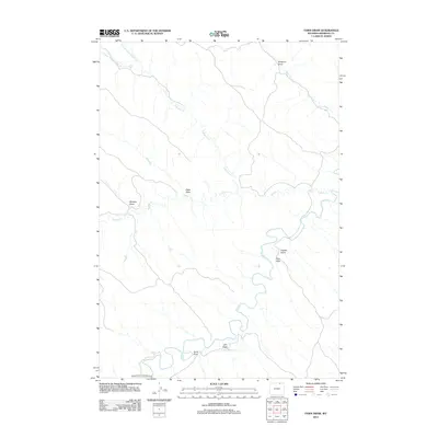
2012 Map of Fawn Draw
USGS Topo · Published 2012About this map
Clear Cr meanders prominently through this portion of Sheridan County, carving a distinct hydrological pattern across the landscape of northeastern Wyoming. The water network is particularly dense here, characterized by the convergence of the N Buffalo Cr and Buffalo Cr systems, alongside the specialized irrigation or storage provided by Cultra Reservoir. This 2012 survey illustrates a terrain defined by its complex drainage basins, where named features like Fawn Draw, Chaffee Gulch, and Sampson Draw indicate a landscape primarily shaped by seasonal runoff and local topography. Human infrastructure is sparse, concentrated on the Arvada-Davis Crossing Rd N along the southern edge, suggesting a quiet, ranch-heavy rural district where land use remains tied to the natural contours of the creek beds and draws like Lake Draw and Scott Draw.
Find a feature on this map
15 named features on this map. Tap any name to fly to it.
Don’t see what you’re looking for? This feature index may not catch every label — zoom into the map to look around manually.
Map Details
Editions of this 2012 Fawn Draw Map
This is the sole edition of this map. No revisions or reprints were ever made.
Other maps of this area

1955 · Sheridan
USGS Topo · 1:250,000

1958 · Sheridan
USGS Topo · 1:250,000

1962 · Sheridan
USGS Topo · 1:250,000

1971 · Cabin Creek NW
USGS Topo · 1:24,000

1971 · Cabin Creek SE
USGS Topo · 1:24,000
1971 · Cabin Creek NE
USGS Topo · 1:24,000

1971 · Arvada
USGS Topo · 1:24,000

1971 · Gardner Gulch
USGS Topo · 1:24,000
1971 · Fawn Draw
USGS Topo · 1:24,000

1971 · Leiter
USGS Topo · 1:24,000