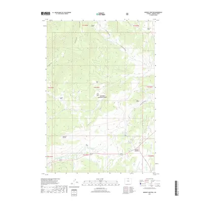
2017 Map of Burgess Junction
USGS Topo · Published 2017About this map
Burgess Junction serves as the primary navigation point in this high-altitude landscape of the Bighorn National Forest. The topography is defined by significant divides and canyons, including the Lake Creek Divide and the dramatic Tongue River Canyon to the east. Water systems are extensive, with the North Tongue River and its various tributaries like Big Willow Cr and Little Willow Cr carving through the mountain terrain. Notable landmarks such as the Garden of the Gods and Twin Buttes provide distinct visual markers for travelers and researchers. Evidence of seasonal land use appears through labels like the Dry Fork Cow Camp, suggesting the area's history with livestock and grazing. This survey captures a balance of wilderness and essential mountain infrastructure, highlighting basins like the Fool Creek Basin alongside established forest access routes.
Find a feature on this map
32 named features on this map. Tap any name to fly to it.
Don’t see what you’re looking for? This feature index may not catch every label — zoom into the map to look around manually.
Map Details
Editions of this 2017 Burgess Junction Map
This is the sole edition of this map. No revisions or reprints were ever made.
Other maps of this area

1895 · Dayton
USGS Topo · 1:125,000

1898 · Bald Mountain
USGS Topo · 1:125,000

1901 · Dayton
USGS Topo · 1:125,000

1901 · Bald Mountain
USGS Topo · 1:125,000

1955 · Sheridan
USGS Topo · 1:250,000

1958 · Sheridan
USGS Topo · 1:250,000

1960 · Granite Pass
USGS Topo · 1:24,000

1960 · Hidden Tepee Creek
USGS Topo · 1:24,000

1962 · Sheridan
USGS Topo · 1:250,000
1964 · Burgess Junction
USGS Topo · 1:24,000