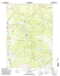
1993 Map of Woodrock
USGS Topo · Published 1997About this map
Bighorn National Forest dominates this mountain landscape, where historical timber and mining operations once relied on the intricate network of waterways flowing from the high country. The South Tongue River and Little Tongue River carve through the terrain, supported by numerous drainages like Sucker Creek and Owen Creek. Evidence of early industrial activity is visible at the Taylor Mine and the distinctive Tie Flum site, reflecting the era's reliance on flumes for transporting logs. Remote outposts such as Woodrock and Cow Camp are situated among prominent peaks like Black Mountain and Lookout Mtn. The survey also marks high-elevation waters including Graves Lake and Duncan Lake, while the presence of a Scenic Byway indicates the transition of this area toward modern recreational use within the forest boundaries of Sheridan and Big Horn counties.
Find a feature on this map
31 named features on this map. Tap any name to fly to it.
Don’t see what you’re looking for? This feature index may not catch every label — zoom into the map to look around manually.
Map Details
Editions of this 1993 Woodrock Map
2 editions found
Other maps of this area

1895 · Dayton
USGS Topo · 1:125,000

1898 · Bald Mountain
USGS Topo · 1:125,000

1901 · Dayton
USGS Topo · 1:125,000

1901 · Bald Mountain
USGS Topo · 1:125,000

1955 · Sheridan
USGS Topo · 1:250,000

1958 · Sheridan
USGS Topo · 1:250,000

1960 · Shell Falls
USGS Topo · 1:24,000

1960 · Granite Pass
USGS Topo · 1:24,000

1962 · Sheridan
USGS Topo · 1:250,000
1964 · Burgess Junction
USGS Topo · 1:24,000