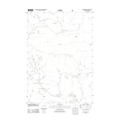
2012 Map of Skull Ridge
USGS Topo · Published 2012About this map
Skull Ridge and its surrounding high-country terrain define this 2012 survey of the Bighorn National Forest region. The landscape is marked by the complex drainage systems of the Tongue River, including the North Tongue River and South Tongue River, which flow through high-elevation flats like Sawmill Flat and Shutts Flats. Human activity in the area is centered on seasonal recreation and livestock management, evidenced by sites such as Yankee Cow Camp and Freeze Out Cow Camp.
Find a feature on this map
40 named features on this map. Tap any name to fly to it.
Don’t see what you’re looking for? This feature index may not catch every label — zoom into the map to look around manually.
Map Details
Editions of this 2012 Skull Ridge Map
This is the sole edition of this map. No revisions or reprints were ever made.
Other maps of this area

1895 · Dayton
USGS Topo · 1:125,000

1898 · Bald Mountain
USGS Topo · 1:125,000

1901 · Dayton
USGS Topo · 1:125,000

1901 · Bald Mountain
USGS Topo · 1:125,000

1955 · Sheridan
USGS Topo · 1:250,000

1958 · Sheridan
USGS Topo · 1:250,000

1960 · Granite Pass
USGS Topo · 1:24,000

1962 · Sheridan
USGS Topo · 1:250,000
1964 · Burgess Junction
USGS Topo · 1:24,000
1964 · Dayton North
USGS Topo · 1:24,000