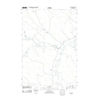
2012 Map of Ucross
USGS Topo · Published 2012About this map
The small settlement of Ucross serves as the focal point of this Sheridan County landscape, situated at the confluence of several vital waterways and irrigation systems. The reliance on water management in this arid region is evident through the extensive network of engineered channels, including the Pratt and Ferris Ditch Number 1, Big Bonanza Ditch, and Athorpe Rogers Ditch. These ditches, alongside features like Pitsch Reservoir and Little Red Reservoir Number 2, demonstrate the agricultural infrastructure required to sustain the land between Blazer Hill and the winding course of Clear Creek. Local travel is defined by rural routes such as Box Elder Road and Big Red Lane, which connect the scattered draws and creek beds that define the topography of northern Wyoming.
Find a feature on this map
28 named features on this map. Tap any name to fly to it.
Don’t see what you’re looking for? This feature index may not catch every label — zoom into the map to look around manually.
Map Details
Editions of this 2012 Ucross Map
This is the sole edition of this map. No revisions or reprints were ever made.
Other maps of this area

1900 · Fort McKinney
USGS Topo · 1:125,000

1903 · Fort McKinney
USGS Topo · 1:125,000

1909 · Sheridan
USGS Topo · 1:125,000

1911 · Sheridan
USGS Topo · 1:125,000

1955 · Sheridan
USGS Topo · 1:250,000

1958 · Sheridan
USGS Topo · 1:250,000

1962 · Sheridan
USGS Topo · 1:250,000

1970 · Buffalo NE
USGS Topo · 1:24,000
1970 · Horse Hill
USGS Topo · 1:24,000
1970 · Verona
USGS Topo · 1:24,000