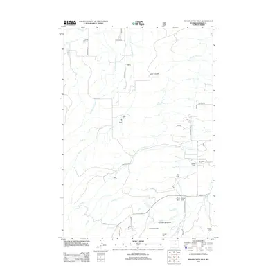
2012 Map of Beaver Creek Hills
USGS Topo · Published 2012About this map
Beaver Creek Hills dominate the high country of Sheridan County in this 2012 topographic study, where a complex network of early irrigation infrastructure remains visible across the landscape. Tracing the water rights of the era, the map identifies significant engineering works such as the Big Goose and Beaver Ditch, Colorado Colony Ditch, and Peralta Ditch. These waterways represent a vital agricultural heritage, directing flow from Big Goose Cr and Jackson Cr to support local ranching and settlement. Evidence of historical access is found along Beckton Hall Rd and the aptly named Red Grade Rd, which navigates the steep ascent toward Government Gap. The terrain is deeply incised by numerous named draws and gulches, including Baker Draw and Alder Gulch, providing a detailed look at the drainage patterns that define this section of the Wyoming range.
Find a feature on this map
56 named features on this map. Tap any name to fly to it.
Don’t see what you’re looking for? This feature index may not catch every label — zoom into the map to look around manually.
Map Details
Editions of this 2012 Beaver Creek Hills Map
This is the sole edition of this map. No revisions or reprints were ever made.
Other maps of this area

1895 · Dayton
USGS Topo · 1:125,000

1901 · Dayton
USGS Topo · 1:125,000

1909 · Sheridan
USGS Topo · 1:125,000

1911 · Sheridan
USGS Topo · 1:125,000

1955 · Sheridan
USGS Topo · 1:250,000

1958 · Sheridan
USGS Topo · 1:250,000

1962 · Sheridan
USGS Topo · 1:250,000

1964 · Wolf
USGS Topo · 1:24,000

1964 · Beckton
USGS Topo · 1:24,000
1964 · Hultz Draw
USGS Topo · 1:24,000