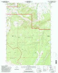
1993 Map of Little Goose Peak
USGS Topo · Published 1997About this map
Gen Crooks Camp and the high ridges of the Bighorn National Forest define this rugged 1993 survey. The landscape is a network of mountain trails and administrative outposts, featuring the Penrose Guard Station and several historical summer grazing sites such as Gallatin Cow Camp and Cow Camp. A complex drainage system feeds into the West Fork and East Fork of Little Goose Creek, with prominent landmarks like Bosin Rock and Little Goose Peak marking the vertical terrain near the Sheridan and Johnson County line.
Find a feature on this map
36 named features on this map. Tap any name to fly to it.
Don’t see what you’re looking for? This feature index may not catch every label — zoom into the map to look around manually.
Map Details
Editions of this 1993 Little Goose Peak Map
This is the sole edition of this map. No revisions or reprints were ever made.
Other maps of this area

1895 · Dayton
USGS Topo · 1:125,000

1899 · Cloud peak
USGS Topo · 1:125,000

1900 · Fort McKinney
USGS Topo · 1:125,000

1901 · Cloud Peak
USGS Topo · 1:125,000

1901 · Dayton
USGS Topo · 1:125,000

1903 · Fort McKinney
USGS Topo · 1:125,000

1909 · Sheridan
USGS Topo · 1:125,000

1911 · Sheridan
USGS Topo · 1:125,000

1955 · Sheridan
USGS Topo · 1:250,000

1958 · Sheridan
USGS Topo · 1:250,000