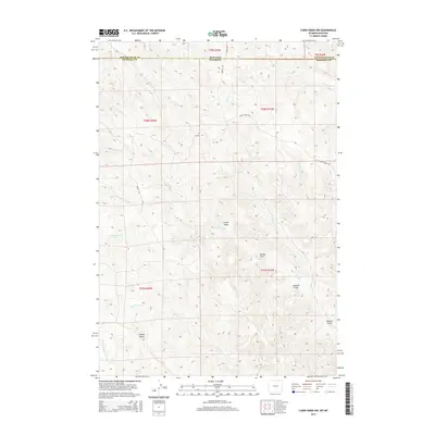
2015 Map of Cabin Creek NW
USGS Topo · Published 2015About this map
The Montana-Wyoming border cuts across the northern edge of this high-plains landscape, where the high point of Squaw Butte overlooks a complex network of drainage draws and seasonal creeks. The terrain is defined by the transition from the Powder River County rangeland into the northern reaches of Sheridan County. Water management and natural flow are central to the geography here, evidenced by the numerous named prongs and draws such as Schoolhouse Prong, Tanney Draw, and Sawmill Draw. Local transport relies on a sparse network of rural routes including Passaic Rd and Fence Creek Rd, which navigate the contours of the Seventysix Creek and Cabin Creek watersheds. This map captures the remote, open-range character of the borderlands during the early 21st century, illustrating how the physical geography dictated the placement of roads and boundary lines.
Find a feature on this map
27 named features on this map. Tap any name to fly to it.
Don’t see what you’re looking for? This feature index may not catch every label — zoom into the map to look around manually.
Map Details
Editions of this 2015 Cabin Creek NW Map
This is the sole edition of this map. No revisions or reprints were ever made.
Other maps of this area

1954 · Hardin
USGS Topo · 1:250,000

1955 · Sheridan
USGS Topo · 1:250,000

1957 · Hardin
USGS Topo · 1:250,000

1958 · Hardin
USGS Topo · 1:250,000

1958 · Sheridan
USGS Topo · 1:250,000

1962 · Sheridan
USGS Topo · 1:250,000

1971 · Cabin Creek NW
USGS Topo · 1:24,000

1971 · Cabin Creek SE
USGS Topo · 1:24,000
1971 · Cabin Creek NE
USGS Topo · 1:24,000

1971 · Gardner Gulch
USGS Topo · 1:24,000