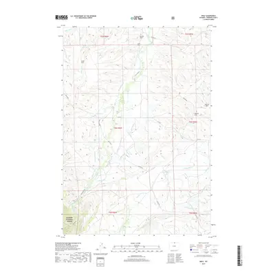
2017 Map of Wolf
USGS Topo · Published 2017About this map
Wolf sits at the base of the eastern slopes where the Bighorn National Forest meets the high plains of Sheridan County. This landscape is defined by an intricate network of irrigation channels, including the Old Reliable Ditch, Alliance Ditch, and Grinnell Ditch, which divert water from mountain-fed streams like Wolf Cr and Soldier Cr to support agricultural life in the foothills. The terrain transitions from the deep cut of Windy Canyon Cr and the heights of the national forest down to a series of named draws such as Lowe Draw and Hammel Draw. Local transport is anchored by roads like Eatons Ranch Rd and Beckton Rd, which provide access to family holdings and remote ranching operations. The presence of the Hanff Reservoir and multiple diversions like the Dye-Shields Ditch underscores the historical reliance on water engineering to manage the arid environment of northern Wyoming.
Find a feature on this map
42 named features on this map. Tap any name to fly to it.
Don’t see what you’re looking for? This feature index may not catch every label — zoom into the map to look around manually.
Map Details
Editions of this 2017 Wolf Map
This is the sole edition of this map. No revisions or reprints were ever made.
Other maps of this area

1895 · Dayton
USGS Topo · 1:125,000

1901 · Dayton
USGS Topo · 1:125,000

1955 · Sheridan
USGS Topo · 1:250,000

1958 · Sheridan
USGS Topo · 1:250,000

1962 · Sheridan
USGS Topo · 1:250,000

1964 · Wolf
USGS Topo · 1:24,000
1964 · Ranchester
USGS Topo · 1:24,000
1964 · Dayton North
USGS Topo · 1:24,000
1964 · Monarch
USGS Topo · 1:24,000

1964 · Dayton South
USGS Topo · 1:24,000