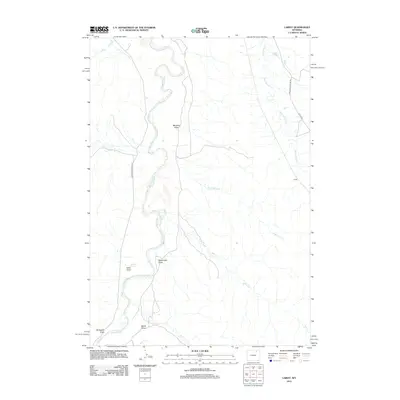
2012 Map of Lariat
USGS Topo · Published 2012About this map
The Powder River meanders through this portion of Campbell County, carving a complex network of seasonal drainages and coulees into the Wyoming landscape. In the early 21st century, the area around Lariat remained a sparsely populated ranching environment defined by its watercourses and topographic depressions. Named features such as Rossnecker Draw, Scroggins Draw, and Stotts Draw indicate a long history of local land use and family associations. One of the more unusual geological points of interest is Catfish Geyser, located west of the river. The map also documents the essential rural road network, including Upper Powder River Rd and Echeta Rd, which provide access to this isolated terrain where several creek systems like Mickelberry Cr and Wild Horse Cr converge toward the main river valley.
Find a feature on this map
19 named features on this map. Tap any name to fly to it.
Don’t see what you’re looking for? This feature index may not catch every label — zoom into the map to look around manually.
Map Details
Editions of this 2012 Lariat Map
This is the sole edition of this map. No revisions or reprints were ever made.
Other maps of this area

1954 · Gillette
USGS Topo · 1:250,000

1955 · Sheridan
USGS Topo · 1:250,000

1955 · Gillette
USGS Topo · 1:250,000

1958 · Gillette
USGS Topo · 1:250,000

1958 · Sheridan
USGS Topo · 1:250,000

1962 · Gillette
USGS Topo · 1:250,000

1962 · Sheridan
USGS Topo · 1:250,000

1971 · Larey Draw
USGS Topo · 1:24,000

1971 · Arvada
USGS Topo · 1:24,000
1971 · Arvada NE
USGS Topo · 1:24,000