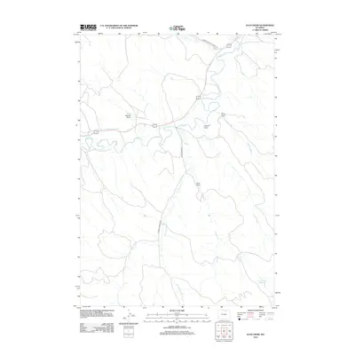
2012 Map of Julio Draw
USGS Topo · Published 2012About this map
Clear Cr meanders through this portion of Sheridan County, shaping a landscape defined by seasonal drainages and early 21st-century water management. The intricate path of Double Crossing Cr dominates the southern half of the quadrangle, illustrating the complex hydrology required to sustain this arid region. Significant infrastructure such as the Pratt and Ferris Ditch Number 1 and the Twin Number 1 Reservoir demonstrate the intersection of natural watercourses and engineered irrigation systems. The terrain is further characterized by numerous topographic depressions known as draws, including Julio Draw, Sahara Draw, and Fowler Draw. Transportation through the area is facilitated by established routes like the Sheridan-Ulm-Clearmont Rd and the locally descriptive Double Cross Rd, which provide access to this wide-open Wyoming ranching landscape.
Find a feature on this map
11 named features on this map. Tap any name to fly to it.
Don’t see what you’re looking for? This feature index may not catch every label — zoom into the map to look around manually.
Map Details
Editions of this 2012 Julio Draw Map
This is the sole edition of this map. No revisions or reprints were ever made.
Other maps of this area

1900 · Fort McKinney
USGS Topo · 1:125,000

1903 · Fort McKinney
USGS Topo · 1:125,000

1909 · Sheridan
USGS Topo · 1:125,000

1911 · Sheridan
USGS Topo · 1:125,000

1955 · Sheridan
USGS Topo · 1:250,000

1958 · Sheridan
USGS Topo · 1:250,000

1962 · Sheridan
USGS Topo · 1:250,000

1970 · Buffalo NE
USGS Topo · 1:24,000
1970 · Ulm
USGS Topo · 1:24,000
1970 · Ucross
USGS Topo · 1:24,000