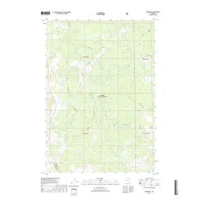
2017 Map of Woodrock
USGS Topo · Published 2017About this map
Bighorn National Forest dominates this high-altitude landscape in northern Wyoming, where the headwaters of the S Tongue River and its numerous forks carve through the timbered terrain. The settlement of Woodrock serves as a central point in an area defined by its hydrology and complex drainage systems, including Copper Creek, Wolf Creek, and Graves Creek. Notable for historians and genealogists are the Taylor Graves located near the northern edge of Graves Lake, providing a specific record of early presence in this backcountry. High-elevation points like Bonanza Lookout, Black Mtn, and Lookout Mtn offer fixed reference points for those tracing old forest routes. Modern recreation and legacy forestry paths are visible in the Woodrock ATV trail and names like Dunwood and Copperwood, reflecting the ongoing human interaction with this mountainous section of the Big Horn range.
Find a feature on this map
37 named features on this map. Tap any name to fly to it.
Don’t see what you’re looking for? This feature index may not catch every label — zoom into the map to look around manually.
Map Details
Editions of this 2017 Woodrock Map
This is the sole edition of this map. No revisions or reprints were ever made.
Other maps of this area

1895 · Dayton
USGS Topo · 1:125,000

1898 · Bald Mountain
USGS Topo · 1:125,000

1901 · Dayton
USGS Topo · 1:125,000

1901 · Bald Mountain
USGS Topo · 1:125,000

1955 · Sheridan
USGS Topo · 1:250,000

1958 · Sheridan
USGS Topo · 1:250,000

1960 · Shell Falls
USGS Topo · 1:24,000

1960 · Granite Pass
USGS Topo · 1:24,000

1962 · Sheridan
USGS Topo · 1:250,000
1964 · Burgess Junction
USGS Topo · 1:24,000