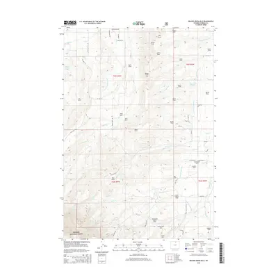
2015 Map of Beaver Creek Hills
USGS Topo · Published 2015About this map
Bighorn National Forest dominates the southwestern portion of this Sheridan County landscape, where the foothills meet the high country at Government Gap. The area is defined by a complex network of man-made irrigation infrastructure, notably the Colorado Colony Ditch, Peralta Ditch, and Big Goose and Beaver Ditch, which redirect water from alpine sources like Big Goose Cr and Beaver Cr to the lower elevations. The map reveals the intricate drainage patterns of the Beaver Creek Hills, characterized by numerous named draws such as Nelson Draw and Wymer Draw. Family-named landmarks and water features, including Jerry Johns Reservoir Number 1 and Bracket Number 3 Reservoir, underscore the importance of water management in this agricultural and ranching region. Roads like Red Grade Rd and Bear Gulch Trl provide access into the steeper terrain of the national forest near Curlew Hill.
Find a feature on this map
78 named features on this map. Tap any name to fly to it.
Don’t see what you’re looking for? This feature index may not catch every label — zoom into the map to look around manually.
Map Details
Editions of this 2015 Beaver Creek Hills Map
This is the sole edition of this map. No revisions or reprints were ever made.
Other maps of this area

1895 · Dayton
USGS Topo · 1:125,000

1901 · Dayton
USGS Topo · 1:125,000

1909 · Sheridan
USGS Topo · 1:125,000

1911 · Sheridan
USGS Topo · 1:125,000

1955 · Sheridan
USGS Topo · 1:250,000

1958 · Sheridan
USGS Topo · 1:250,000

1962 · Sheridan
USGS Topo · 1:250,000

1964 · Wolf
USGS Topo · 1:24,000

1964 · Beckton
USGS Topo · 1:24,000
1964 · Hultz Draw
USGS Topo · 1:24,000