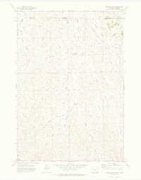
1971 Map of Roundup Draw
USGS Topo · Published 1974About this map
Hanging Woman Creek and its various prongs dominate this 1971 topographical study of the high plains straddling the Montana and Wyoming border. This sparsely populated ranching landscape is defined by an intricate network of seasonal watercourses and drainage basins, including the prominently labeled Antelope Draw and Box Elder Creek. The map documents a territory where human activity is marked primarily by scattered infrastructure such as the Antelope Res and various drill holes, reflecting the region's intersection of livestock grazing and early energy exploration.
Find a feature on this map
17 named features on this map. Tap any name to fly to it.
Don’t see what you’re looking for? This feature index may not catch every label — zoom into the map to look around manually.
Map Details
Editions of this 1971 Roundup Draw Map
This is the sole edition of this map. No revisions or reprints were ever made.
Other maps of this area

1909 · Sheridan
USGS Topo · 1:125,000

1911 · Sheridan
USGS Topo · 1:125,000

1954 · Hardin
USGS Topo · 1:250,000

1955 · Sheridan
USGS Topo · 1:250,000

1957 · Hardin
USGS Topo · 1:250,000

1958 · Hardin
USGS Topo · 1:250,000

1958 · Sheridan
USGS Topo · 1:250,000

1962 · Sheridan
USGS Topo · 1:250,000
1967 · Pine Butte School
USGS Topo · 1:24,000
1970 · O T O Ranch
USGS Topo · 1:24,000