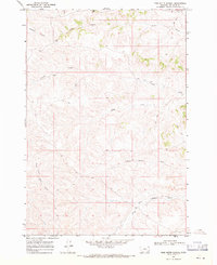
1967 Map of Pine Butte School
USGS Topo · Published 1971About this map
Pine Butte School serves as a lone landmark in this mid-1960s landscape of Big Horn County, Montana. The terrain is characterized by a complex drainage system where waterways like Anderson Creek, First Creek, and Corral Creek carve through the high plains. The map reveals a land defined more by its natural hydrology than by dense human settlement, with the winding North Fork Deer Creek and Waddle Creek anchoring the southern portion of the survey. Significant relief is evident in the transition between the South Fork and the deeply etched John Reavis Draw. Transportation in the area during this era was largely limited to rugged networks, indicated by a prominent Jeep Trail that crosses the creek beds, reflecting the remote ranching or resource extraction character of the region. A solitary Gravel Pit near the northern boundary suggests localized industrial activity amidst the vast cattle country.
Find a feature on this map
14 named features on this map. Tap any name to fly to it.
Don’t see what you’re looking for? This feature index may not catch every label — zoom into the map to look around manually.
Map Details
Editions of this 1967 Pine Butte School Map
This is the sole edition of this map. No revisions or reprints were ever made.
Other maps of this area

1909 · Sheridan
USGS Topo · 1:125,000

1911 · Sheridan
USGS Topo · 1:125,000

1954 · Hardin
USGS Topo · 1:250,000

1955 · Sheridan
USGS Topo · 1:250,000

1957 · Hardin
USGS Topo · 1:250,000

1958 · Hardin
USGS Topo · 1:250,000

1958 · Sheridan
USGS Topo · 1:250,000

1962 · Sheridan
USGS Topo · 1:250,000

1967 · Holmes Ranch
USGS Topo · 1:24,000

1967 · Lacey Gulch
USGS Topo · 1:24,000