
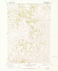
1967 Map of Holmes Ranch
USGS Topo · Published 1971About this map
Holmes Ranch and Porter Ranch are the primary human focal points in this high-plains landscape of Big Horn County, mapped during the mid-1960s. The terrain is defined by a complex network of ephemeral drainages and broken ridges, where the Badger Hills rise in the southern portion of the quadrangle. This area of Montana shows a sparse ranching economy where settlement is dictated by the availability of water along the various forks and creeks.
Find a feature on this map
11 named features on this map. Tap any name to fly to it.
Don’t see what you’re looking for? This feature index may not catch every label — zoom into the map to look around manually.
Map Details
Editions of this 1967 Holmes Ranch Map
2 editions found
Other maps of this area

1909 · Sheridan
USGS Topo · 1:125,000

1911 · Sheridan
USGS Topo · 1:125,000

1954 · Hardin
USGS Topo · 1:250,000

1955 · Sheridan
USGS Topo · 1:250,000

1957 · Hardin
USGS Topo · 1:250,000

1958 · Hardin
USGS Topo · 1:250,000

1958 · Sheridan
USGS Topo · 1:250,000

1962 · Sheridan
USGS Topo · 1:250,000

1967 · Tongue River Dam
USGS Topo · 1:24,000

1967 · Lacey Gulch
USGS Topo · 1:24,000