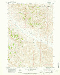
1970 Map of Cedar Canyon
USGS Topo · Published 1973About this map
Badger Hills dominate this 1970 landscape, where the high plains of northern Wyoming meet the Montana border. This high-country survey by the U.S. Geological Survey captures a sparse ranching environment defined by wide drainage networks and isolated landmarks. The presence of the X Bar Ranch and E Bar U Ranch indicates the primary land use of the era, situated among named watercourses like Badger Creek and Little Badger Creek. The map provides specific locational data for rural infrastructure, marking a Quarry, various Well locations, and a Drill Hole, reflecting the mineral and water exploration common to Sheridan Co and Big Horn Co. These industrial markers are interspersed between local topographic features such as Cedar Canyon, Windmill Draw, and Prong Creek, offering a clear view of the territorial boundary as it was managed in the early 1970s.
Find a feature on this map
16 named features on this map. Tap any name to fly to it.
Don’t see what you’re looking for? This feature index may not catch every label — zoom into the map to look around manually.
Map Details
Editions of this 1970 Cedar Canyon Map
This is the sole edition of this map. No revisions or reprints were ever made.
Other maps of this area

1909 · Sheridan
USGS Topo · 1:125,000

1911 · Sheridan
USGS Topo · 1:125,000

1954 · Hardin
USGS Topo · 1:250,000

1955 · Sheridan
USGS Topo · 1:250,000

1957 · Hardin
USGS Topo · 1:250,000

1958 · Hardin
USGS Topo · 1:250,000

1958 · Sheridan
USGS Topo · 1:250,000

1962 · Sheridan
USGS Topo · 1:250,000

1967 · Holmes Ranch
USGS Topo · 1:24,000
1967 · Pine Butte School
USGS Topo · 1:24,000