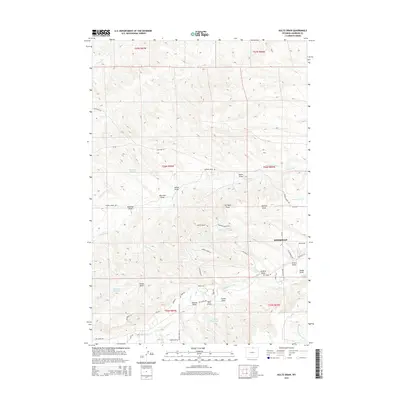
2015 Map of Hultz Draw
USGS Topo · Published 2015About this map
Sheridan borders the eastern edge of this landscape, where the high plains meet a complex network of seasonal drainages and irrigation infrastructure. The terrain is defined by numerous draws, such as Hultz Draw and Warriner Draw, which channel runoff toward more permanent watercourses like Big Goose Creek and Soldier Cr. Human intervention in this arid environment is evident through an extensive system of water management features, including the Colorado Colony Ditch, Alliance Ditch, and several private impoundments like Fryberger Reservoir and Garrett Reservoir. These systems reflect the historical necessity of diverting water for agricultural and residential use in Sheridan County. The road network, including Cavalry Ridge Rd and George Crook Ln, provides access to the ridgelines and valleys that have supported ranching and development on the city's outskirts into the early 21st century.
Find a feature on this map
55 named features on this map. Tap any name to fly to it.
Don’t see what you’re looking for? This feature index may not catch every label — zoom into the map to look around manually.
Map Details
Editions of this 2015 Hultz Draw Map
This is the sole edition of this map. No revisions or reprints were ever made.
Other maps of this area

1895 · Dayton
USGS Topo · 1:125,000

1901 · Dayton
USGS Topo · 1:125,000

1909 · Sheridan
USGS Topo · 1:125,000

1911 · Sheridan
USGS Topo · 1:125,000

1955 · Sheridan
USGS Topo · 1:250,000

1958 · Sheridan
USGS Topo · 1:250,000

1962 · Sheridan
USGS Topo · 1:250,000

1964 · Wolf
USGS Topo · 1:24,000
1964 · Ranchester
USGS Topo · 1:24,000
1964 · Monarch
USGS Topo · 1:24,000