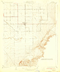
1933 Map of Arvin
USGS Topo · Published 1933About this map
Agricultural development in the southern San Joaquin Valley is the defining characteristic of this area during the early 1930s. The burgeoning town of Arvin serves as a central hub for the surrounding fields, supported by a rigid grid of transit corridors like Comanche Drive and Bear Mtn Boulevard. To the north, the settlement of Di Giorgio marks the reach of large-scale fruit production, while Vaccaro sits further south along the foothills. The landscape is a study in the hard transition from engineered irrigation to natural terrain, with the Eastside Canal cutting across the valley floor before the land rises sharply into the Tejon Hills. This survey, conducted by F. H. Purdy, illustrates the early 20th-century reliance on canal systems and primary roads to transform the arid valley into a productive hinterland. In the eastern uplands, the topography becomes dramatically intricate where Sycamore Canyon and Little Sycamore Canyon carve through the rising elevation near Comanche Point.
Find a feature on this map
20 named features on this map. Tap any name to fly to it.
Don’t see what you’re looking for? This feature index may not catch every label — zoom into the map to look around manually.
Map Details
Editions of this 1933 Arvin Map
3 editions found

Other maps of this area

1914 · Caliente
USGS Topo · 1:125,000

1929 · Bena
USGS Topo · 1:31,680

1929 · Fairfax School
USGS Topo · 1:31,680

1930 · Weed Patch
USGS Topo · 1:31,680

1930 · Bear Mountain
USGS Topo · 1:31,680

1930 · Arvin
USGS Topo · 1:31,680

1931 · West of Tejon Hills
USGS Topo · 1:31,680

1931 · Edison
USGS Topo · 1:31,680

1931 · Tejon Hills
USGS Topo · 1:31,680

1932 · Bena
USGS Topo · 1:31,680