
1967 Map of Ash Creek
USGS Topo · Published 1969About this map
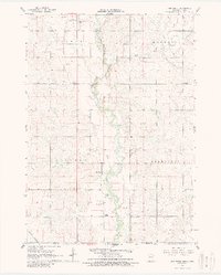
The Rock River meanders south through the borderlands of Minnesota and Iowa in this late-1960s survey. The landscape is defined by the rural townships of Clinton, Kanaranzi, Luverne, and Magnolia, where the small settlement of Ash Creek serves as a local hub. The map provides a high-resolution view of mid-century agricultural land use, even detailing specific fence and field lines visible from aerial photography. Local life is anchored by landmarks such as Ebenezer Ch and the Eastside Cem, while School No 1839 stands as a marker of the area's educational history. Near the northern edge, the Luverne Municipal Airport and various Gravel Pits indicate the developing infrastructure and resource extraction supporting the community during this era.
Find a feature on this map
16 named features on this map. Tap any name to fly to it.
Don’t see what you’re looking for? This feature index may not catch every label — zoom into the map to look around manually.
Map Details
Editions of this 1967 Ash Creek Map
2 editions found
Other maps of this area

1955 · Sioux Falls
USGS Topo · 1:250,000

1958 · Sioux Falls
USGS Topo · 1:250,000

1967 · Magnolia
USGS Topo · 1:24,000

1967 · Hills
USGS Topo · 1:24,000

1967 · Hills NE
USGS Topo · 1:24,000

1967 · Ellsworth
USGS Topo · 1:24,000
1967 · Luverne
USGS Topo · 1:24,000

1971 · Edna
USGS Topo · 1:24,000

1971 · Lester
USGS Topo · 1:24,000

1971 · Rock Rapids
USGS Topo · 1:24,000