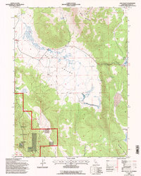
1993 Map of Ash Valley
USGS Topo · Published 1996About this map
Ash Valley is defined by a complex hydraulic landscape of ditches, levees, and reservoirs at the base of Knox Mountain. This 1993 revision, conducted by the U.S. Forest Service, illustrates the ranching and resource management character of northeastern California. Evidence of local history and land use is found in features like Fleming Sheep Camp and a small Cem located near the center of the valley floor. Water remains the primary shaper of human activity here, with Ash Creek feeding into a network of managed water sources, including Holbrook Reservoir and Spooner Reservoir. The western portion of the map transitions into the Modoc National Forest, where the terrain rises toward Oxendine Spring and Diaz Spring. Several small pits and a Gravel Pit suggest localized mineral extraction or road maintenance during this period.
Find a feature on this map
28 named features on this map. Tap any name to fly to it.
Don’t see what you’re looking for? This feature index may not catch every label — zoom into the map to look around manually.
Map Details
Editions of this 1993 Ash Valley Map
This is the sole edition of this map. No revisions or reprints were ever made.
Other maps of this area

1886 · Alturas
USGS Topo · 1:250,000

1886 · Honey Lake
USGS Topo · 1:250,000

1891 · Honey Lake
USGS Topo · 1:250,000

1892 · Alturas
USGS Topo · 1:250,000

1893 · Honey Lake
USGS Topo · 1:250,000

1954 · Grasshopper Valley
USGS Topo · 1:62,500

1954 · Alturas
USGS Topo · 1:250,000

1955 · Westwood
USGS Topo · 1:250,000

1956 · Hayden Hill
USGS Topo · 1:62,500

1958 · Alturas
USGS Topo · 1:250,000