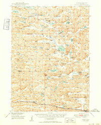
1949 Map of Ashby
USGS Topo · Published 1949About this map
Ashby anchors the southern portion of this landscape, situated along the tracks of the Chicago Burlington and Quincy railroad as it cuts through the Nebraska Sandhills. The area is characterized by a series of northwest-to-southeast valleys, such as Hospital Valley and Camp Valley, interspersed with numerous lakes and alkaline basins like Alkali Lake and Mother Lake. The settlement pattern reflects the cattle-ranching economy of the late 1940s, with widely dispersed operations including the JHL Ranch, Ferguson Ranch, and Diamond Bar Ranch dotting the terrain. This map captures a moment when rural education was localized in small district buildings like Ferguson-Becker Sch, Keller Sch, and Consolidated Sch, serving families across the Cherry County and Grant County line. The abundance of flowing wells and dipping vats printed here provides a clear record of the infrastructure required for high-plains ranching during this period.
Find a feature on this map
48 named features on this map. Tap any name to fly to it.
Don’t see what you’re looking for? This feature index may not catch every label — zoom into the map to look around manually.
Map Details
Editions of this 1949 Ashby Map
3 editions found
Other maps of this area

1948 · Ashby
USGS Topo · 1:62,500

1948 · Bingham
USGS Topo · 1:62,500

1948 · Spade Ranch
USGS Topo · 1:62,500

1948 · George Lake
USGS Topo · 1:62,500

1948 · Whitman
USGS Topo · 1:62,500

1948 · Spring Valley
USGS Topo · 1:62,500

1949 · Ashby
USGS Topo · 1:62,500

1949 · Steverson Lake
USGS Topo · 1:62,500

1949 · Turpin Lake
USGS Topo · 1:62,500

1950 · Spring Valley
USGS Topo · 1:62,500