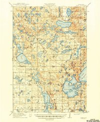
1913 Map of Ashby
USGS Topo · Published 1949About this map
Glacial lakes and rural schoolhouses define this corner of West Central Minnesota during the early twentieth century. The landscape is a dense network of water bodies, from the large basins of Stalker Lake and Tenmile Lake to smaller features like Rosvold Lake and Jolly Ann Lake. The Great Northern RR and Northern Pacific RR provide the primary transit corridors, supporting the growth of Dalton and Ashby. This period represents a highly decentralized educational era, evidenced by the numbered school districts scattered across the townships, including School No 126 and School No 4. Along the Pomme de Terre River, a Mill Pond suggests local industry integrated with the water system. The map also records early administrative boundaries where Otter Tail Co, Grant Co, and Douglas Co meet.
Find a feature on this map
68 named features on this map. Tap any name to fly to it.
Don’t see what you’re looking for? This feature index may not catch every label — zoom into the map to look around manually.
Map Details
Editions of this 1913 Ashby Map
4 editions found
Other maps of this area

1910 · Wendell
USGS Topo · 1:62,500

1911 · Barrett
USGS Topo · 1:62,500

1911 · Herman
USGS Topo · 1:62,500

1912 · Battle Lake
USGS Topo · 1:62,500

1913 · Ashby
USGS Topo · 1:62,500

1913 · Fergus Falls
USGS Topo · 1:62,500

1913 · Wendell
USGS Topo · 1:62,500

1914 · Battle Lake
USGS Topo · 1:62,500

1915 · Underwood
USGS Topo · 1:62,500

1953 · Milbank
USGS Topo · 1:250,000