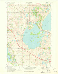
1973 Map of Ashby
USGS Topo · Published 1975About this map
The town of Ashby serves as the central hub of this 1970s landscape, positioned near the intersection of the Burlington Northern railroad and several glacial water bodies. The geography is defined by a dense network of lakes and marshes, most notably the expansive Pelican Lake and the northern reaches of Lake Christina. These waters were heavily managed for conservation during this era, evidenced by the extensive National Waterfowl Production Area and State Wildlife Management Area tracts. Local history and genealogy are preserved at the Pelican Lake Cem and Erdahl Cem. The transition from rail-dependent industry to a more recreational and conservation-focused economy is visible in the presence of an Old Railroad Grade and several Gravel Pits alongside modern boat ramps. Small family-named waters like Werson Lake and Anderson Lake dot the western terrain, illustrating the localized nature of the rural drainage system.
Find a feature on this map
31 named features on this map. Tap any name to fly to it.
Don’t see what you’re looking for? This feature index may not catch every label — zoom into the map to look around manually.
Map Details
Editions of this 1973 Ashby Map
This is the sole edition of this map. No revisions or reprints were ever made.
Other maps of this area

1911 · Barrett
USGS Topo · 1:62,500

1913 · Ashby
USGS Topo · 1:62,500

1953 · Brainerd
USGS Topo · 1:250,000

1953 · Saint Cloud
USGS Topo · 1:250,000

1957 · Brainerd
USGS Topo · 1:250,000

1957 · Saint Cloud
USGS Topo · 1:250,000

1958 · Saint Cloud
USGS Topo · 1:250,000

1958 · Brainerd
USGS Topo · 1:250,000

1965 · Brainerd
USGS Topo · 1:250,000

1966 · Quam Lake
USGS Topo · 1:24,000