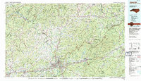
1985 Map of Asheville
USGS Topo · Published 1985About this map
The Blue Ridge Mountains and the hub city of Asheville dominate this mid-1980s landscape, reflecting a region defined by high-elevation topography and significant public land holdings. Centered on the confluence of the French Broad River and the Swannanoa River, the map shows the suburban expansion of Biltmore Forest and Skyland alongside older industrial corridors following the Southern Railway. To the northeast, the Black Mountains rise to Mount Mitchell, protected within Pisgah National Forest and Mount Mitchell State Park.
Find a feature on this map
163 named features on this map. Tap any name to fly to it.
Don’t see what you’re looking for? This feature index may not catch every label — zoom into the map to look around manually.
Map Details
Editions of this 1985 Asheville Map
2 editions found
Other maps of this area

1883 · Morristown
USGS Topo · 1:125,000

1891 · Cowee
USGS Topo · 1:125,000

1891 · Roan Mountain
USGS Topo · 1:125,000

1892 · Greeneville
USGS Topo · 1:125,000

1893 · Cranberry
USGS Topo · 1:125,000

1893 · Mt Guyot
USGS Topo · 1:125,000

1893 · Morristown
USGS Topo · 1:125,000

1894 · Asheville
USGS Topo · 1:125,000

1894 · Roan Mountain
USGS Topo · 1:125,000

1895 · Morristown
USGS Topo · 1:125,000