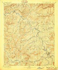
1894 Map of Asheville
USGS Topo · Published 1897About this map
The French Broad River carves a deep path through this late 19th-century landscape, serving as the primary corridor for the Western North Carolina Railroad as it winds past Hot Springs and Barnard. This survey captures a pivotal moment for Asheville, showing the early footprint of Biltmore and the developing town sites of Weaverville and Mars Hill. Away from the rail lines, the economy is clearly driven by the mountain water network, with industrial sites like Gadders Mill, Wells Mill, and Pendletons Mill situated along the creeks.
Find a feature on this map
139 named features on this map. Tap any name to fly to it.
Don’t see what you’re looking for? This feature index may not catch every label — zoom into the map to look around manually.
Map Details
Editions of this 1894 Asheville Map
2 editions found
Other maps of this area

1883 · Morristown
USGS Topo · 1:125,000

1891 · Cowee
USGS Topo · 1:125,000

1891 · Roan Mountain
USGS Topo · 1:125,000

1892 · Greeneville
USGS Topo · 1:125,000

1893 · Mt Guyot
USGS Topo · 1:125,000

1893 · Morristown
USGS Topo · 1:125,000

1894 · Asheville
USGS Topo · 1:125,000

1894 · Roan Mountain
USGS Topo · 1:125,000

1895 · Morristown
USGS Topo · 1:125,000

1896 · Greeneville
USGS Topo · 1:125,000