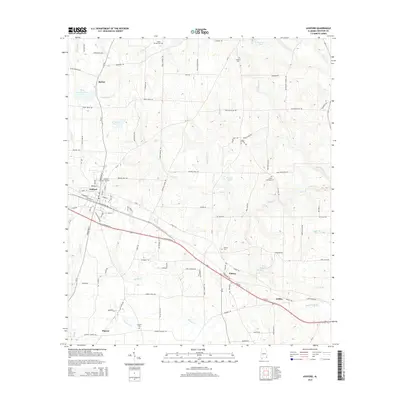
2014 Map of Ashford
USGS Topo · Published 2014About this map
Ashford sits at the heart of this East Alabama landscape, where the local economy was long defined by its road and rail connections. The map reveals a dense network of country roads like Hurricane Rd and Cedar Springs Rd that link small rural settlements such as Barber and Pansey. For those tracing local history, several prominent burial grounds are documented, including Ashford City Cem and Union Springs Cem. The topography is shaped by numerous small drainages, with the waters of Cedar Cr and Rocky Cr winding through the terrain toward Howards Mill Cr. From the northern reaches near Hunters Cem to the southern area around Dupree, the map captures a modern view of Houston County's traditional agricultural and residential patterns.
Find a feature on this map
102 named features on this map. Tap any name to fly to it.
Don’t see what you’re looking for? This feature index may not catch every label — zoom into the map to look around manually.
Map Details
Editions of this 2014 Ashford Map
This is the sole edition of this map. No revisions or reprints were ever made.
Other maps of this area

1953 · Dothan
USGS Topo · 1:250,000

1954 · Dothan
USGS Topo · 1:250,000

1955 · Dothan
USGS Topo · 1:250,000

1969 · Dothan East
USGS Topo · 1:24,000

1969 · Headland
USGS Topo · 1:24,000
1969 · Cottonwood
USGS Topo · 1:24,000

1970 · Gordon
USGS Topo · 1:24,000
1970 · Saffold
USGS Topo · 1:24,000

1970 · Sigma
USGS Topo · 1:24,000

1970 · Columbia
USGS Topo · 1:24,000