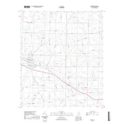
2020 Map of Ashford
USGS Topo · Published 2020About this map
The town of Ashford serves as a central hub in this Houston County landscape, where agriculture and utility infrastructure intersect. The map documents the corridor of Old US Hwy 84 and Pansey Rd connecting the primary settlement to the smaller community of Pansey and the location of Dupree. Genealogists will find several burial grounds mapped, including the Ashford City Cem, Hunters Cem, and Antioch Cem. The terrain is defined by a dense network of tributaries including Cedar Cr, Rocky Cr, and Howards Mill Cr, which feed into larger water bodies like Glenn Lawrence Lake and Bruce Blaum Lake. This 2020 edition captures the modern road grid, including the proximity of the Nuclear Plant Rd corridor, while still reflecting the historical distribution of family-named landmarks like Garners Pond and Hollis Meadows Br.
Find a feature on this map
86 named features on this map. Tap any name to fly to it.
Don’t see what you’re looking for? This feature index may not catch every label — zoom into the map to look around manually.
Map Details
Editions of this 2020 Ashford Map
This is the sole edition of this map. No revisions or reprints were ever made.
Other maps of this area

1953 · Dothan
USGS Topo · 1:250,000

1954 · Dothan
USGS Topo · 1:250,000

1955 · Dothan
USGS Topo · 1:250,000

1969 · Dothan East
USGS Topo · 1:24,000

1969 · Headland
USGS Topo · 1:24,000
1969 · Cottonwood
USGS Topo · 1:24,000

1970 · Gordon
USGS Topo · 1:24,000
1970 · Saffold
USGS Topo · 1:24,000

1970 · Sigma
USGS Topo · 1:24,000

1970 · Columbia
USGS Topo · 1:24,000