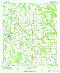
1970 Map of Ashford
USGS Topo · Published 2000About this map
The town of Ashford serves as the primary hub of this East Alabama landscape, centered on the Seaboard Coast Line railroad. This 1970 field-checked survey reveals a rural society structured around numerous community churches and local schools, such as the Ashford Academy and Grimsley Sch. Small settlements like Pansey, Ardilla, and Barber are connected by a network of secondary roads and local creeks, including Rocky Creek and Cedar Springs Creek.
Find a feature on this map
43 named features on this map. Tap any name to fly to it.
Don’t see what you’re looking for? This feature index may not catch every label — zoom into the map to look around manually.
Map Details
Editions of this 1970 Ashford Map
This is the sole edition of this map. No revisions or reprints were ever made.
Other maps of this area

1953 · Dothan
USGS Topo · 1:250,000

1954 · Dothan
USGS Topo · 1:250,000

1955 · Dothan
USGS Topo · 1:250,000

1969 · Dothan East
USGS Topo · 1:24,000

1969 · Headland
USGS Topo · 1:24,000
1969 · Cottonwood
USGS Topo · 1:24,000

1970 · Gordon
USGS Topo · 1:24,000
1970 · Saffold
USGS Topo · 1:24,000

1970 · Sigma
USGS Topo · 1:24,000

1970 · Columbia
USGS Topo · 1:24,000