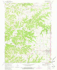
1969 Map of Ashland
USGS Topo · Published 1982About this map
Rock Bridge Memorial State Park anchors the northern reaches of this Boone County landscape, protecting natural landmarks like the Devils Icebox and Conners Cave. The topography is defined by the winding paths of Bonne Femme Creek and Turkey Creek, which carve deep drainages through the central terrain. Near the community of Pierpont, the University of Missouri Environmental Health Research Facilities occupy a significant tract of land, while smaller crossroads like Sapp and Elkhurst dot the rural horizon. To the south, the town of Ashland serves as a primary hub, complete with its High Sch and municipal Sewage Disposal Pond infrastructure. For those researching local history, the map preserves the locations of numerous country churches and burial grounds, including the Log Providence Ch, New Salem Ch, and family landmarks such as Samuel Cem and Harris Cem.
Find a feature on this map
35 named features on this map. Tap any name to fly to it.
Don’t see what you’re looking for? This feature index may not catch every label — zoom into the map to look around manually.
Map Details
Editions of this 1969 Ashland Map
2 editions found
Other maps of this area

1886 · Jefferson City
USGS Topo · 1:125,000

1894 · Jefferson City
USGS Topo · 1:125,000

1935 · Columbia
USGS Topo · 1:24,000

1939 · Jefferson City
USGS Topo · 1:62,500

1940 · Columbia
USGS Topo · 1:24,000

1942 · Jefferson City
USGS Topo · 1:62,500

1944 · Millersburg
USGS Topo · 1:62,500

1946 · Millersburg
USGS Topo · 1:62,500

1947 · Jefferson City
USGS Topo · 1:250,000

1948 · Centertown
USGS Topo · 1:62,500