
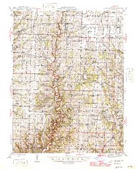
1946 Map of Millersburg
USGS Topo · Published 1946About this map
Cedar Creek winds prominently through the center of this mid-1940s landscape, serving as the natural boundary between Boone and Callaway counties. The area is characterized by a dense network of rural infrastructure, including a remarkably high concentration of country schools such as Duncan Sch, Boydsville Sch, and New Richland Sch. This era captures the transition of the local economy, where early river-and-creek crossings like Rutherford Bridge and Duley Mill Bridge stand alongside more modern developments like the Airway Beacon near Lindbergh. Community life is anchored by small settlements such as Millersburg and Stephens, while the southern reaches are dominated by the University of Missouri Game Preserve. Scattered strip mines point to active resource extraction during this post-war period.
Find a feature on this map
89 named features on this map. Tap any name to fly to it.
Don’t see what you’re looking for? This feature index may not catch every label — zoom into the map to look around manually.
Map Details
Editions of this 1946 Millersburg Map
2 editions found
Other maps of this area

1886 · Jefferson City
USGS Topo · 1:125,000

1890 · Mexico
USGS Topo · 1:125,000

1890 · Moberly
USGS Topo · 1:125,000

1890 · Fulton
USGS Topo · 1:125,000

1894 · Jefferson City
USGS Topo · 1:125,000

1917 · Sturgeon
USGS Topo · 1:62,500

1928 · Fulton
USGS Topo · 1:62,500

1931 · Fulton
USGS Topo · 1:62,500

1932 · Mexico
USGS Topo · 1:62,500

1935 · Columbia
USGS Topo · 1:24,000