
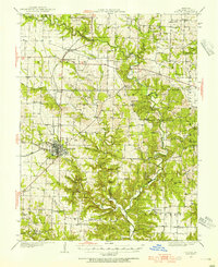
1928 Map of Fulton
USGS Topo · Published 1954About this map
Fulton serves as the focal point of this central Missouri landscape, where the Chicago and Alton rail line cuts through the western terrain to connect the county seat with outlying hamlets. The map reveals a highly developed rural social fabric, evidenced by an exceptional density of country schools such as St Eunice Sch, Garden Prairie Sch, and Maddox Sch. These local institutions, often named for nearby families or geographic features, highlight the community's decentralized structure before mid-century school consolidations.
Find a feature on this map
78 named features on this map. Tap any name to fly to it.
Don’t see what you’re looking for? This feature index may not catch every label — zoom into the map to look around manually.
Map Details
Editions of this 1928 Fulton Map
2 editions found
Other maps of this area

1886 · Jefferson City
USGS Topo · 1:125,000

1890 · Mexico
USGS Topo · 1:125,000

1890 · Moberly
USGS Topo · 1:125,000

1890 · Fulton
USGS Topo · 1:125,000

1894 · Jefferson City
USGS Topo · 1:125,000

1931 · Fulton
USGS Topo · 1:62,500

1932 · Mexico
USGS Topo · 1:62,500

1935 · Morrison
USGS Topo · 1:48,000

1939 · Jefferson City
USGS Topo · 1:62,500

1940 · Montgomery City
USGS Topo · 1:62,500