
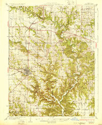
1931 Map of Fulton
USGS Topo · Published 1931About this map
The city of Fulton serves as the hub of this 1930s landscape, where the Chicago and Alton RR and several early highways converge. The surrounding Callaway County terrain is a complex network of rural school districts and parish centers, many of which are identified by family-named schools like St Eunice Sch and Dahmer Sch. Outside the city, the land breaks into deep hollows such as Spring Hollow and Maddox Hollow as it slopes toward the winding path of Auxvasse Creek. Small rural crossroads like Kingdom City and McCredie illustrate the early development of the region's transportation corridors. Of particular note for local historians are the numerous country churches, including the Old Auxvasse Ch and Harmony Ch, which anchored these upland farming communities before the era of modern consolidation.
Find a feature on this map
78 named features on this map. Tap any name to fly to it.
Don’t see what you’re looking for? This feature index may not catch every label — zoom into the map to look around manually.
Map Details
Editions of this 1931 Fulton Map
2 editions found
Other maps of this area

1886 · Jefferson City
USGS Topo · 1:125,000

1890 · Mexico
USGS Topo · 1:125,000

1890 · Moberly
USGS Topo · 1:125,000

1890 · Fulton
USGS Topo · 1:125,000

1894 · Jefferson City
USGS Topo · 1:125,000

1928 · Fulton
USGS Topo · 1:62,500

1932 · Mexico
USGS Topo · 1:62,500

1935 · Morrison
USGS Topo · 1:48,000

1939 · Jefferson City
USGS Topo · 1:62,500

1940 · Montgomery City
USGS Topo · 1:62,500