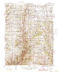
1946 Map of Millersburg
USGS Topo · Published 1946About this map
Cedar Creek carves a winding path through this mid-1940s landscape, marking the boundary between the townships of Columbia, Cedar, and Bourbon. The map captures a transition in land use, from the expansive University of Missouri Game Preserve in the southwest to active Strip Mine operations near Stephens. The settlement of Millersburg sits at a crossroads, surrounded by a dense network of country schools like Boydsville Sch and Branch Sch, which suggest a well-populated rural community of the era.
Find a feature on this map
81 named features on this map. Tap any name to fly to it.
Don’t see what you’re looking for? This feature index may not catch every label — zoom into the map to look around manually.
Map Details
Editions of this 1946 Millersburg Map
2 editions found

Other maps of this area

1886 · Jefferson City
USGS Topo · 1:125,000

1890 · Mexico
USGS Topo · 1:125,000

1890 · Moberly
USGS Topo · 1:125,000

1890 · Fulton
USGS Topo · 1:125,000

1894 · Jefferson City
USGS Topo · 1:125,000

1917 · Sturgeon
USGS Topo · 1:62,500

1928 · Fulton
USGS Topo · 1:62,500

1931 · Fulton
USGS Topo · 1:62,500

1932 · Mexico
USGS Topo · 1:62,500

1935 · Columbia
USGS Topo · 1:24,000