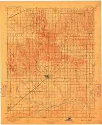
1896 Map of Ashland
USGS Topo · Published 1910About this map
Ashland serves as the focal point of this late 19th-century survey of Clark County, Kansas, situated at the junction of a developing rail network and a complex drainage system. The Atchison Topeka and Santa Fe R R cuts a diagonal path across the prairie, connecting settlements like Sitka and Englewood while following the subtle natural corridors between the Cimarron River and various northern creeks. This era shows the landscape transitioning from open range to a more structured township system, though prominent landmarks like Mt Jesus and the essential water source at St Jacobs Well remain critical navigation points for travelers and ranchers.
Find a feature on this map
57 named features on this map. Tap any name to fly to it.
Don’t see what you’re looking for? This feature index may not catch every label — zoom into the map to look around manually.
Map Details
Editions of this 1896 Ashland Map
3 editions found
Other maps of this area

1889 · Kinsley
USGS Topo · 1:125,000

1892 · Kinsley
USGS Topo · 1:125,000

1892 · Meade
USGS Topo · 1:125,000

1892 · Dodge
USGS Topo · 1:125,000

1892 · Spearville
USGS Topo · 1:125,000

1892 · Coldwater
USGS Topo · 1:125,000

1894 · Spearville
USGS Topo · 1:125,000

1894 · Kinsley
USGS Topo · 1:125,000
1894 · Sitka
USGS Topo · 1:62,500
1896 · Ashland
USGS Topo · 1:125,000