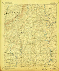
1891 Map of Ashland
USGS Topo · Published 1917About this map
Ashland stands as the central hub of this late-nineteenth-century landscape, surrounded by a complex network of ridges and watercourses. The economy of the era is clearly visible through numerous industrial markers, including several water-powered facilities like Hillabee Mill and Rice Mill, along with a localized resource extraction point at Graphite. The topography is dominated by the Talladega Mts. and Blue Ridge, where named landmarks such as Pulpit Rock and Cheaha Mt. overlook a terrain defined by gaps like Odom Gap and Emory Gap.
Find a feature on this map
141 named features on this map. Tap any name to fly to it.
Don’t see what you’re looking for? This feature index may not catch every label — zoom into the map to look around manually.
Map Details
Editions of this 1891 Ashland Map
5 editions found
Other maps of this area

1889 · Tallapoosa
USGS Topo · 1:125,000

1889 · Springville
USGS Topo · 1:125,000

1890 · Talladega
USGS Topo · 1:125,000

1891 · Ashland
USGS Topo · 1:125,000

1892 · Springville
USGS Topo · 1:125,000

1892 · Talladega
USGS Topo · 1:125,000

1892 · Tallapoosa
USGS Topo · 1:125,000

1897 · Tallapoosa
USGS Topo · 1:125,000

1899 · Wedowee
USGS Topo · 1:125,000

1900 · Anniston
USGS Topo · 1:125,000