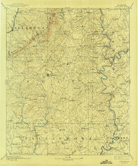
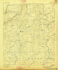
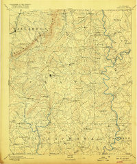
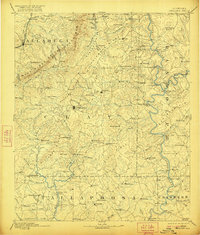
1891 Map of Ashland
USGS Topo · Published 1943About this map
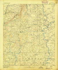
Ashland sits at the center of this 1880s survey, surrounded by the diverse topography of the Blue Ridge and Shinbone Ridge. The industrial character of the era is evident in the presence of Graphite mining and local milling operations like Hillabee Mill and Young Mill. Transport in this rugged landscape relied on the Anniston and Atlantic RR in the northwest, while numerous fords such as Hutchinson Ford and Sandy Ford provided critical crossings over Big Hillabee Creek and its tributaries. Small agricultural and pioneer settlements like Pinckneyville, Mellow Valley, and Hackneyville are well-defined, offering a clear view of eastern Alabama's interior before the expansion of modern road networks. The prominence of Cheaha Mountain and the designated Talladega National Forest land highlights the area's transition from early extraction and farming to conservation and public land management.
Find a feature on this map
138 named features on this map. Tap any name to fly to it.
Don’t see what you’re looking for? This feature index may not catch every label — zoom into the map to look around manually.
Map Details
Editions of this 1891 Ashland Map
5 editions found
Other maps of this area

1889 · Tallapoosa
USGS Topo · 1:125,000

1889 · Springville
USGS Topo · 1:125,000

1890 · Talladega
USGS Topo · 1:125,000
1891 · Ashland
USGS Topo · 1:125,000

1892 · Springville
USGS Topo · 1:125,000

1892 · Talladega
USGS Topo · 1:125,000

1892 · Tallapoosa
USGS Topo · 1:125,000

1897 · Tallapoosa
USGS Topo · 1:125,000

1899 · Wedowee
USGS Topo · 1:125,000

1900 · Anniston
USGS Topo · 1:125,000